|
| ||||||
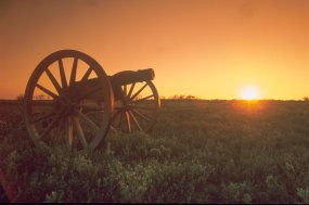
Palo Alto Battlefield National Historic Site Brownsville, TX 78520 On May 8, 1846 troops of the United States and Mexico clashed on the prairie of Palo Alto in the first battle of a two-year war. Signed into law in June 1992, Palo Alto Battlefield National Historic Site preserves the 3,400-acre scene of this clash between nations and informs visitors about its national and international importance. As the only unit of the National Park Service with a primary focus on the U.S.-Mexican War, Palo Alto Battlefield also interprets the entire conflict--including the details of its origins and the broad range of consequences. In an effort to turn a scene of conflict into a place of bi-national exchange and understanding, all research and interpretation conducted by the park reflects perspectives of both the United States and Mexico. | ||||||
Calculate the distance to the Palo Alto Battlefield National Historic Site by entering your 5-digit zip code:  | ||||||
Plane - Brownsville is readily accessible via a number of area airports. The closest terminal is the Brownsville/South Padre Island International Airport in Brownsville. Other options include airports in Harlingen, Texas, McAllen, Texas, and Matamoros, Mexico. Car - Palo Alto Battlefield N.H.S. lies at the northeast corner of the intersection of FM 1847 ( Paredes Line Road) and FM 511, approximately five miles north of downtown Brownsville, TX. From Rt. 77/83 take the FM 511 exit and drive east approximately two miles to reach FM 1847. The park visitor center is located on the east side of 1847, 1,000 feet north of the intersection. | ||||||
 | ||||||
 Palo Alto Battlefield National Historic Site | Museum / Visit | |||||