|
| ||||||
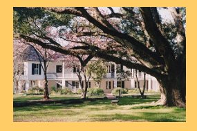
Cane River National Heritage Area Natchitoches, LA 71458 Cane River National Heritage Area in northwestern Louisiana is a largely rural, agricultural landscape known for its historic plantations, its distinctive Creole architecture, and its multi-cultural legacy. Historically this region lay at the intersection of French and Spanish realms in the New World. Today it is home to a unique blend of cultures, including French, Spanish, African, American Indian, and Creole. The central corridor of the heritage area begins just south of Natchitoches, the oldest permanent settlement in the Louisiana Purchase, and extends along both sides of Cane River Lake for approximately 35 miles. The heritage area includes Cane River Creole National Historical Park, seven National Historic Landmarks, three State Historic Sites, and many other historic plantations, homes, and churches. While much of the roughly 116,000-acre heritage area is privately owned, many sites are open to the public. | ||||||
Calculate the distance to the Cane River National Heritage Area by entering your 5-digit zip code:  | ||||||
Car - Cane River Creole National Historical Park headquarters is at 400 Rapides Drive in Natchitoches, LA. To reach the Oakland Plantation unit, take I-49 to Exit 127, the Flora/Cypress exit. Head east one and one-half miles on Highway 120. Cross over Highway 1 on to Highway 494. Proceed four miles on Highway 494 to Oakland Plantation. | ||||||
 Cane River National Heritage Area | Touring by Auto Bicycling Boating Camping Fishing Groceries Available Hiking Picnic Area Restaurant / Snacks Museum / Visit Water Sports | |||||