|
| ||||||
Curecanti National Recreation Area Gunnison, CO 81230 Three reservoirs, named for corresponding dams on the Gunnison River, form the heart of Curecanti National Recreation Area. Panoramic mesas, fjord-like reservoirs, and deep, steep and narrow canyons abound. Blue Mesa Reservoir is Colorado's largest body of water, and is the largest Kokanee Salmon fishery in the United States. Morrow Point Reservoir is the beginning of the Black Canyon of the Gunnison and below, Crystal Reservoir is the site of the Gunnison Diversion Tunnel, a National Historic Civil Engineering Landmark. Recently discovered dinosaur fossils, a 5,000 acre archeological district, a narrow gauge train, and traces of 6000 year old dwellings further enhance the offerings of Curecanti. | ||||||
Calculate the distance to the Curecanti National Recreation Area by entering your 5-digit zip code:  | ||||||
Plane - Commercial airlines to Denver, Gunnison, Montrose, and Grand Junction airports. Car - Via Highway 50 which runs the length of the recreation area between Montrose and Gunnison, Colorado (approximately 200 miles SW of Denver) and is easily accessed from CO Hwy 149, and CO Hwy 92. Public Transportation - By bus: To Gunnison, Montrose, and Grand Junction By train: To Grand Junction | ||||||
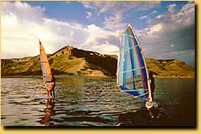 Curecanti National Recreation Area | Touring by Auto Boating Climbing Camping Fishing Groceries Available Hiking Horseback Riding Hunting Picnic Area Restaurant / Snacks Museum / Visit Water Sports Winter Sports Wildlife Viewing | |||||