|
| ||||||
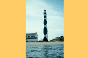
Cape Lookout National Seashore Harkers Island, NC 28531 The seashore is a 56 mile long section of the Outer Banks of North Carolina running from Ocracoke Inlet on the northeast to Beaufort Inlet on the southeast. The three undeveloped barrier islands which make up the seashore - North Core Banks, South Core Banks and Shackleford Banks - may seem barren and isolated but they offer many natural and historical features that can make a visit very rewarding | ||||||
Calculate the distance to the Cape Lookout National Seashore by entering your 5-digit zip code:  | ||||||
Car - Cape Lookout National Seashore's Visitor Center is located on the eastern end of Harkers Island, approximately 20 mi (30 km) east of Beaufort, NC and 30 mi (50 km)south of the Cedar Island terminus of the North Carolina State Ferry route from Ocracoke Island to Cedar Island. From Beaufort: Take U.S. 70 east to Harkers Island Road (SR 1332/SR 1335). From Cedar Island: Take SR 12 south past the Atlantic turnoff to US 70 west. Continue on US 70 to Harkers Island Road (SR1332/SR 1335) . Follow Harkers Island Road until it terminates. On the left is the two-story visitor center. Public Transportation - Cape Lookout National Seashore is accessible only through private ferries leaving from Harkers Island, Davis, Atlantic, Beaufort, Morehead City and Ocracoke or your personal boat. Ferries leaving from the communities of Harkers Island, Beaufort, Morehead City and Ocracoke, NC carry passengers only. The ferries from Davis and Atlantic, NC can transport passengers and 4-wheel drive | ||||||
 Cape Lookout National Seashore | Boating Camping Fishing Hiking Hunting Lodging Available Picnic Area Museum / Visit Water Sports Wildlife Viewing | |||||