|
| ||||||
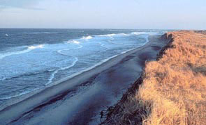
Cape Cod National Seashore Wellfleet, MA 02667 Cape Cod National Seashore comprises 43,604 acres of shoreline and upland landscape features, including a forty-mile long stretch of pristine sandy beach, dozens of clear, deep, freshwater kettle ponds, and upland scenes that depict evidence of how people have used the land. A variety of historic structures are within the boundary of the Seashore, including lighthouses, a lifesaving station, and numerous Cape Cod style houses. The Seashore offers six swimming beaches, eleven self-guiding nature trails, and a variety of picnic areas and scenic overlooks. | ||||||
Calculate the distance to the Cape Cod National Seashore by entering your 5-digit zip code:  | ||||||
Plane - Regularly scheduled daily flights connect from Boston to Hyannis and Boston to Provincetown. Car - From Boston area: Take Route 3 south, to the Sagamore Bridge in Bourne. Follow Route 6 eastward to Eastham and Provincetown. From Providence, RI: Take I-95 north to, I-195. Follow Route 6 eastward as described above. Public Transportation - By bus: Plymouth and Brockton Street Railway provides daily runs from Boston to Hyannis and the Outer Cape (Provincetown). Bonanza Bus Lines provides several scheduled runs from New York City and Providence, RI to Hyannis, MA (approximately 30 miles southwest of Eastham). By Rail: Amtrak serves Providence, RI and Boston, MA connecting with bus transportation to Cape Cod. | ||||||
 Cape Cod National Seashore | Touring by Auto Bicycling Boating Fishing Hiking Horseback Riding Hunting Lodging Available Picnic Area Restaurant / Snacks Museum / Visit Water Sports Winter Sports Wildlife Viewing | |||||