|
| ||||||
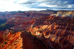
Cedar Breaks National Monument Cedar City, UT 84720 A huge natural amphitheater has been eroded out of the variegated Pink Cliffs (Claron Formation) near Cedar City, Utah. Millions of years of sedimentation, uplift and erosion have created a deep canyon of rock walls, fins, spires and columns, that spans some three miles, and is over 2,000 feet deep. The rim of the canyon is over 10,000 feet above sea level, and is forested with islands of Englemann spruce, subalpine fir and aspen; separated by broad meadows of brilliant summertime wild flowers. | ||||||
Calculate the distance to the Cedar Breaks National Monument by entering your 5-digit zip code:  | ||||||
Car - Visitors traveling south on I-15, exit at Parowan, then take Utah Highway 143 east, to Cedar Breaks National Monument. Visitors traveling north, on I-15 exit at Cedar City, then take Utah Highway 14 east for 18 miles, then Utah Highway 148 north, 4 miles to Cedar Breaks National Monument. Visitors traveling north/south on U.S. Highway 89, can take either Utah Highway 143 from Panguitch to Cedar Breaks, or Utah Highway 14 west, to Utah Highway 148, and north to Cedar Breaks National Monument. | ||||||
 Cedar Breaks National Monument | Touring by Auto Camping Hiking Picnic Area Museum / Visit Winter Sports Wildlife Viewing | |||||