|
| ||||||
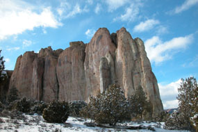
El Morro National Monument Ramah, NM 87321 Rising 200 feet above the valley floor, this massive sandstone bluff was a welcome landmark for weary travelers. A reliable waterhole hidden at its base made El Morro (or Inscription Rock) a popular campsite. Beginning in the late 1500s Spanish, and later, Americans passed by El Morro. While they rested in its shade and drank from the pool, many carved their signatures, dates, and messages. Before the Spanish, petroglyphs were inscribed by Ancestral Puebloans living on top of the bluff over 700 years ago. Today, El Morro National Monument protects over 2,000 inscriptions and petroglyphs, as well as Ancestral Puebloan ruins. Proclaimed Dec. 8, 1906. Boundary changes: June 18, 1917; June 14, 1950. Acreage: 1,278.72 - Federal: 1,039.92; Non-federal: 238.80. | ||||||
Calculate the distance to the El Morro National Monument by entering your 5-digit zip code:  | ||||||
Car - 56 miles southeast of Gallup, NM via Highways 602 and 53; 42 miles southwest of Grants, NM via Highway 53. Public Transportation - No public transportation to the area. | ||||||
 El Morro National Monument | Camping Hiking Picnic Area Museum / Visit | |||||